1739 BC – year when the Sumerian civilization collapsed

Sumerians are known as the founders of the urban civilization that dominated in southern Mesopotamia in the 4th and 3rd millennia BC. They developed a network of irrigation channels that made it possible to cultivate cereals in desert areas of the Lower Euphrates, introduced an ideographic script, initially pictographic and then simplified to the form of cuneiform characters impressed in wet clay, built the biggest cities in the world at that time, with monumental temples and enormous palaces.

Najważniejsze miasta południowej Mezopotamii pod koniec III tysiąclecia p.n.e. Sumer rozciąga się od Eridu do Nippur, obszar między Kisz a Sippar był zamieszkany przez Akadów, a w II tysiącleciu stanowił trzon państwa babilońskiego. Na mapie został zaznaczony przybliżony zasięg Zatoki Perskiej na przełomie III i II tysiąclecia Near_East_topographic_map-blank.svg: Sémhur (na podstawie licencji CC BY-SA 3.0, via Wikimedia Commons)
The most important cities of Mesopotamia in the late 3rd millennium BC. Sumer stretches from Erid to Nippur, the region between Kish and Sippar was occupied by Akkadians, then in the 2nd millennium it was the core of the Babylonian state. The map shows the range of the Persian Gulf in the late 3rd and early 2nd millennium BC
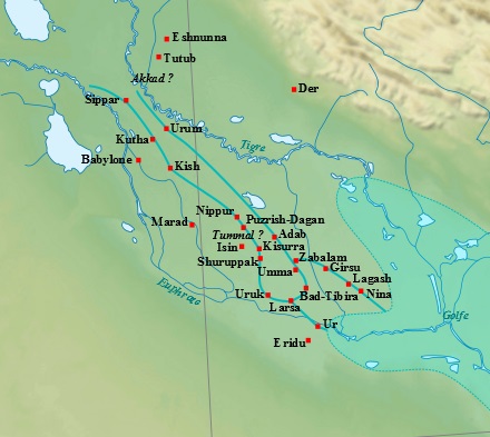
Near_East_topographic_map-blank.svg: Sémhur(published under CC BY-SA 3.0, via Wikimedia Commons)

Continue reading “1739 BC – year when the Sumerian civilization collapsed”